OmniLoc.AI delivers a next-generation, hardware-agnostic localization platform enabling reliable positioning in GPS-denied and GPS-degraded environments.
HD Mapping & CrossView Geolocalization
Fusing perspectives for absolute accuracy.
Our proprietary SLAM technology aligns ground-level data with satellite imagery in real-time. By locking onto precise environmental features, we eliminate GPS drift entirely.
Scalable Hardware Sets
Hyper-Sensing & Data Enhancement.
Modular product kits designed to elevate affordable hardware to premium-grade performance through advanced AI, ensuring trustworthy perception for any autonomous system.
TDA4x
8 TOPSLow-power edge AI for cost-sensitive autonomous platforms and embedded vision systems.
AM69A
32 TOPSHigh-performance multi-sensor fusion for advanced ADAS and autonomous navigation.
Jetson Orin
275 TOPSMaximum throughput for multi-camera, LiDAR-fused perception and real-time HD mapping.
Cloud / Hybrid
∞ ScaleContainerized microservices for fleet-wide localization, HD map generation, and analytics at scale.
Signal Correction
Seamless correction from noisy GPS to absolute positioning.
Jammed Signal Recovery
Robust operation and instant recovery when standard signals are jammed and lost.
Denied Environment
Maintaining full autonomy in environments with absolutely no signal.
Automotive Crossview
Ground vehicle (automotive) crossview localization demonstration.
Aerial Autonomy
Expanding perception beyond the horizon.
From autonomous drones surveying critical infrastructure to unmanned surface vessels navigating coastal waters and ground vehicles operating in dense urban environments — Omniloc's localization stack adapts to any domain, delivering reliable centimeter-level positioning regardless of platform or environment.
Where Others Fail, Omniloc Succeeds
State-of-the-art visual localization breaks down in repetitive environments. We don't.
From above, many places look almost identical — roads, fields, rooftops, tree rows, parking lines, solar panels, industrial yards. Standard matchers can lock onto a place that looks right locally but is geographically wrong. The hard part isn't finding a visual match — it's avoiding the wrong one.
Why Other Solutions Get Lost in Repetitive Scenes
Visual similarity alone produces many plausible matches in repetitive overhead patterns. OmniLoc adds geometry gating — fusing visual similarity with geographic consistency so only the genuinely correct location survives.
Many lookalike candidates score highly. The matcher commits to a convincing but geographically wrong tile — a silent, catastrophic localization error.
Geometry gating rejects the misleading lookalikes. Only the geo-consistent match survives, delivering a verified, drift-free lock.
See It in the Field
Watch OmniLoc CrossView maintain lock where conventional localization drifts in real, repetitive environments.
Real-world demonstration · vehicle, drone and USV footage.
- ✗ Cumulative position drift in feature-poor scenes
- ✗ Loop closure failure in repetitive structures
- ✗ Feature aliasing causes catastrophic localization errors
- ✗ No absolute reference — relies entirely on relative motion
- ✓ Satellite-anchored absolute positioning eliminates drift
- ✓ CrossView matching provides global reference at every frame
- ✓ Multi-sensor fusion compensates for visual ambiguity
- ✓ Proven in GPS-denied, jammed, and spoofed conditions
Our Competitive Advantages
Why OEMs and integrators choose OmniLoc over conventional localization stacks.
Software-First & Hardware-Agnostic
One localization stack deployable across vehicles, drones and USVs — running on TI TDA4x, AM69A, NVIDIA Orin and other edge silicon, or scaled as a cloud service.
Geometry-Gated CrossView
We treat visual similarity and geographic consistency together, rejecting the convincing-but-wrong lookalikes that defeat standard matchers in repetitive scenes.
Centimetre-Level Accuracy
Satellite-anchored absolute positioning delivers cm-level accuracy with no cumulative drift — locked frame after frame.
Up to 90% Sensor-Cost Reduction
Physics-informed AI super-resolves low-cost sensors and uses free global satellite data, cutting reliance on €10K–50K LiDAR suites.
GPS-Denied, Jammed & Spoofed Ready
Proven to hold lock in tunnels, urban canyons and contested environments where GNSS is unreliable, degraded or under attack.
Validated & IP-Backed
TRL-7 validated technology built on Athena Research Center IP, advancing toward industrial deployment through active OEM proof-of-concepts.
How We Compare
Across the five capabilities that matter most, OmniLoc is engineered to satisfy them all at once.
| Standard Visual Matching | Conventional SLAM / VO | Premium LiDAR Suite | OmniLoc AI | |
|---|---|---|---|---|
| Accuracy | ~ | ~ | ✓ | ✓ |
| Real-time speed | ✓ | ~ | ~ | ✓ |
| GPS-denied operation | ~ | ✓ | ✓ | ✓ |
| Repetitive-scene robustness | ✕ | ✕ | ~ | ✓ |
| Scalable & flexible architecture | ~ | ~ | ✕ | ✓ |
| Low hardware cost | ✓ | ✓ | ✕ | ✓ |
| Where it runs | Edge | Edge | Edge | Edge + Cloud |
Comparison reflects typical solution archetypes in GPS-denied localization; OmniLoc is the only approach engineered to satisfy accuracy, speed, GPS-denied operation, repetitive-scene robustness and a scalable, flexible architecture together.
Challenge Environments Where We Excel
Highway Corridors
Repetitive lane markings and uniform infrastructure cause conventional visual odometry to drift. Omniloc's satellite fusion maintains absolute lock.
Urban Canyons
GPS multipath and signal blockage from tall buildings. CrossView geolocalization provides positioning where GNSS cannot reach.
Warehouse & Industrial
Identical aisles and structures defeat feature-based SLAM. Our approach anchors position through overhead satellite alignment.
Open Sea & Coastal
Featureless water surfaces with no visual landmarks. Satellite-fused localization provides reliable positioning for USV operations.
Trusted Across Critical Industries
Active proof-of-concept deployments with leading OEMs and system integrators.
Defense
Autonomous navigation for UGVs, UAVs, and UWVs in contested and GPS-denied theatres. Reliable real-time localization for mission-critical operations where signal integrity cannot be guaranteed.
Critical Infrastructure Protection
Autonomous perimeter monitoring and asset tracking for energy installations, ports, and transportation networks. Persistent situational awareness without reliance on vulnerable GNSS signals.
Public Safety
Real-time situational awareness for first responders and law enforcement. Drone-based localization for rapid deployment in emergency scenarios where existing infrastructure may be compromised.
Civil Protection
Disaster response and search-and-rescue operations with coordinated USV and drone teams. Centimeter-level positioning for damage assessment and survivor location in post-disaster environments.
Our Story
What We Do
OmniLoc delivers AI-driven localization solutions that enable autonomous systems to operate reliably even in GPS-denied environments. By fusing multi-sensor data with satellite imagery and advanced computer vision, our technology provides precise, real-time positioning and scene understanding.
Our framework leverages cooperative learning and efficient AI models to achieve high accuracy with reduced data and energy requirements, while ensuring scalability through model optimization and deployment tools.
The result is centimeter-level, real-time localization and enhanced environmental awareness, improving safety, reliability, and performance across autonomous vehicles, drones, robotics, and defense applications.
Our Leadership
Motivated by a strong commitment to bring cutting-edge localization technologies into real-world applications, OmniLoc was founded by a team with extensive experience in AI, computer vision, and autonomous systems.
The team has contributed as Principal Investigators and Technical Coordinators in several EU-funded projects and industrial R&D contracts, with work spanning perception, localization, security, and autonomous driving technologies.
OmniLoc develops advanced AI-driven localization solutions that fuse multi-sensor and satellite data to enable precise, reliable positioning, even in GPS-denied environments, enhancing the safety and efficiency of autonomous vehicles, drones, and robotic systems.
Technological Roadmap
Precision localization everywhere.
Research & Development
Analysis, understanding, scene prediction, and control of the vehicle, UAV, or semi-autonomous robotic systems used in precision applications, in order to rapidly eliminate operational risks.
Short-Term Solutions
- Deployment of pilot projects with key partners (e.g., drones, autonomous vehicles, warehouse robotics) using the existing online service
- Integration of the platform into customer systems via APIs/SDKs for rapid adoption
- Optimization of cross-view geolocalization models for specific use cases (logistics, UAVs, defense)
- Validation in real-world environments to improve robustness under GPS-denied and degraded conditions
- Expansion of early customer base through targeted B2B collaborations
Long-Term Vision
- Establish OmniLoc.AI as the global standard software layer for GPS-independent localization
- Enable full autonomy across industries by eliminating reliance on expensive hardware and unreliable GPS
- Scale into international markets (automotive, defense, smart logistics, robotics ecosystems)
- Develop a unified, real-time geospatial intelligence platform combining localization, mapping, and situational awareness
- Power next-generation multi-agent autonomous systems with seamless, cooperative perception worldwide
The Team
The brilliant minds driving Omniloc's innovation.

Aris Lalos
Founder & CEO
Alexandros Gkillas
Chief Technical Officer & AI Engineer
Christos Anagnostopoulos
Senior Platform & Simulation Engineer
Nikos Piperigkos
Senior Signal Processing & AI Engineer
Nikos Poulopoulos
Computer Vision Engineer
Evgenia Orfanou
Communication and Project Administrator
Ioulia Kapsali
Computer Vision Engineer
Nikolas Potamianos
Computer Vision Engineer
Andreas Katsaros
Computer Vision EngineerLatest News
Check out the new article about OmniLoc.ai in Startupper.gr! 📰✨

Startupper.gr has highlighted OmniLoc.ai as one of Greece’s emerging deep-tech companies, following our win at the Startup World Cup Greece 2026 during BEYOND.The article presents how OmniLoc is developing AI-based localisation technologies for autonomous systems operating in GPS-degraded and GPS-denied...
Read more →OmniLoc Wins Startup World Cup Greece 2026: Next Stop San Francisco

🏆 We are incredibly proud to announce that OmniLoc has been named the winner of the Startup World Cup Greece 2026! 🇬🇷🚀This achievement earns us the opportunity to represent Greece at the Startup World Cup Grand Finale in San Francisco,...
Read more →Science Agora Networking & Pitch Elevation event
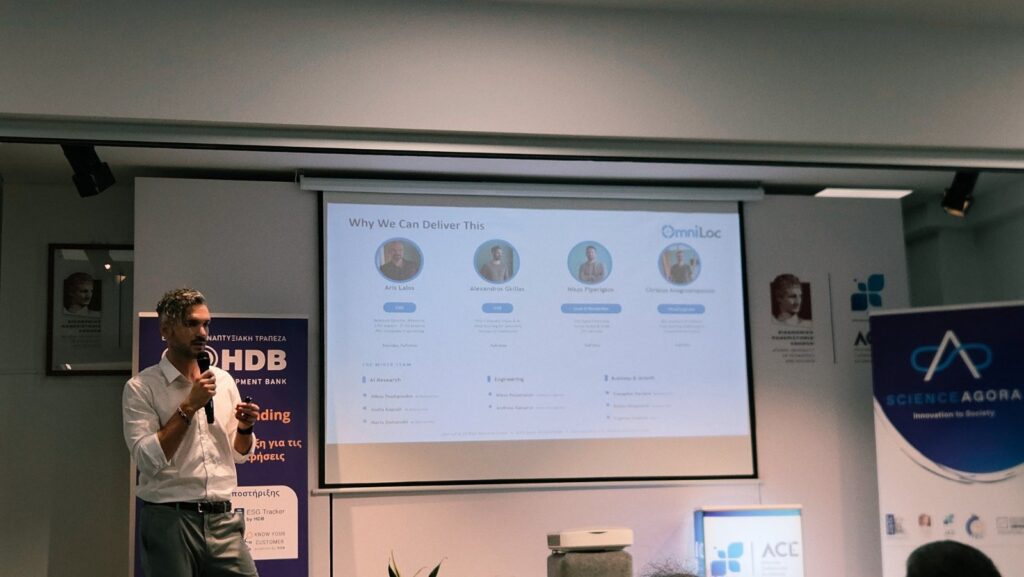
On 12 June 2026, the OmniLoc team participated in the Science Agora Networking & Pitch Elevation event, part of the Proof-of-Concept for Emerging Technologies programme, implemented by Science Agora – Innovation To Society in collaboration with the Hellenic Development Bank...
Read more →Partners & Supporters
Backed by world-class institutions and programs.


Ready to Elevate Your Perception?
Schedule a live demonstration of the Omniloc platform.
See our HD Mapping, Hyper-Sensing Kits, and AI algorithms in action. Pick a time that works for you, and our engineers will walk you through a custom technical overview.